13 March 2014
There are probably as many theories about the movements of barramundi and other species of fish as there are different lures designed to catch them.
Researchers from Charles Darwin University and NT Fisheries are using radio-tracking technology to find out where barramundi and forktail catfish are moving throughout the wet season. The findings will feed into a project investigating the key factors that support aquatic species, and the importance of connectivity between the floodplain, river and ocean.
Previous research shows that the floodplains are a very important habitat for barramundi at certain stages in their life cycle, for example when they are growing and reproducing. The results from this research will ensure that policy and management decisions regarding our fisheries and their habitats can be made using sound scientific evidence.
While it is clear that species like barramundi and catfish use floodplain habitats at times, there are many things we don’t know:
By answering these questions, we can develop our understanding of how the ecosystem functions, and what’s required to preserve our treasured fisheries.
Radio-tracking
The initial field work took place in the Yellow Waters area of Kakadu National Park. Yellow Waters is at the junction of Jim Jim Creek and the South Alligator River. The river system, which is the largest in Kakadu, contains extensive wetlands that include river channels, floodplains and backwater swamps.
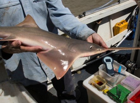
Barramundi were caught in October 2013 and January 2014 by electrofishing, while forktail catfish were collected by hook and line in October 2013. Radio-transmitters were surgically implanted into 40 barramundi and 30 catfish and their movements were tracked by boat and helicopter every two weeks until May 2014.
Each fish has its own story
Since beginning the radio-tracking, we have seen a range of fascinating behaviours. Overall, the barramundi moved up to 30 km from where they were released, while the catfish moved up to 20 km.
Following the first major rainfall in early December, there was a big spike in fish movement, with some fish moving several kilometres out onto the floodplains and even disappearing altogether from the 3,000 square km area being surveyed by helicopter.
With receding waters the majority of fish have moved back to the billabong system they were tagged in. In many cases their last location in May was within a couple of hundred metres from their original tagging location.
Here are some examples: 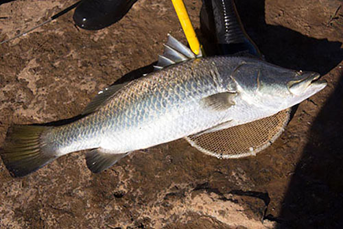
This 450 mm barramundi was collected by electrofishing in Mardugul Billabong on October 8, 2013. It made regular movements of up to 2 km between Mardugul Billabong and Home Billabong during October and November, before moving downstream to Yellow Waters in early December after the first significant flows of the wet season. It was detected back upstream in Home Billabong on December 18 and stayed in that area using the main channel and flooded side-channels throughout January. Following heavy rains in late January, the fish left the billabongs and moved approximately 30 km downstream where it was recorded in a side-channel near the South Alligator River on February 4.
The following fortnight on February 18 the fish had returned to the floodplain immediately adjacent to Yellow Water Billabong. The fish then moved into Home Billabong and has been detected moving locally between Home and Mardugul billabongs. Its last location in May 2014 was in Mardugul Billabong only 70 m from where it was tagged in October 2013.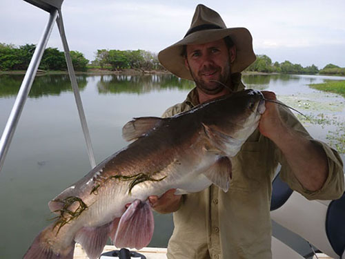
This 410 mm catfish was collected by hook and line from Mardugul Billabong on October 8, 2013. It was detected within a very restricted area (approximately 30 m) around the same 5 m deep hole throughout October and early November. Following the first minor flow increase in mid-November, the fish moved out of the hole and was detected 100 m upstream in Mardugul Billabong.
As the water levels rose in early December, the fish moved 8 km downstream and was detected on the inundated floodplain downstream of Yellow Waters on December 4. It then moved back upstream and was detected near its original location in Mardugul Billabong on December 18. The fish was detected 4 km downstream on the floodplain near Yellow Waters in early January and had moved a further 8 km downstream by late January. It continued to move downstream and was detected in early February, more than 20 km from its original tagging location.
In mid February the catfish had moved back upstream 11 km and continued to move upstream. By early March it was located just 5 km from its original tagging location, where it remained in this floodplain area just downstream from Yellow Waters until early April. On April 15 the fish had returned to within 120 m of its tagging location in Mardugul Billabong, where it remained.
Want to know more about the Resilient Landscapes Hub's activities and our research into practical solutions to environmental problems? Stay informed about activities, research, publications, events and more through the Hub newsletter.
"*" indicates required fields