2 April 2014
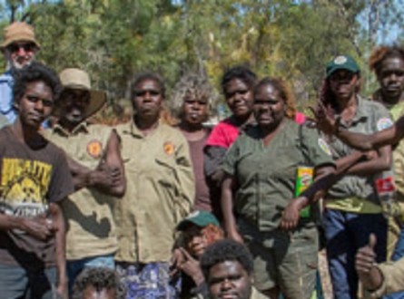
Indigenous rangers and Traditional Owners from the Warddeken Indigenous Protected Area have been working with scientists to monitor native mammal numbers and the impact of feral cats on their country. 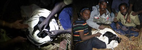
The group has produced a short video about the research, conducted with technical support from the Northern Territory Department of Land Resource Management and Charles Darwin University. It was filmed on Kordwalewale and Ngolkwarre land on the Arnhem Land plateau, north of Kakadu in the Northern Territory.
Across Australia, it’s estimated feral cats are killing up to 75 million native mammals, insects and reptiles per night. Researchers and land managers are trying to better understand the role of cats in animal decline.
For the past two years, the Warddeken people have used their extensive local and cultural knowledge to select wildlife survey locations, set up motion sensing camera trap arrays, and track animal prints.
Using the Indigenous rangers’ highly developed tracking skills, the group covered up to 15 kilometres each day on foot through remote plateau country. Over several months, the 200km network of paths established was revisited to determine how common feral cats are in the landscape.
The Warddeken people first got involved in the research because they were concerned about the disappearance of native animals from their country, and maintaining cultural knowledge for future generations.
Warddeken Land Management Senior Ranger Terah Guymala says feral cats are considered a threat to culture.
“Native animals are important in our culture because they have a connection with us and we have a connection with them and to the land,” Terah said.
“We want our native animals to come back. Feral cats are threatening our culture by killing our native animals ‐ they have no cultural connection to us or the land.”
Apart from regular field surveys, the group has been spotlighting at night. In October last year they worked with Australian Wildlife Conservancy and their specially trained cat‐detection dogs to catch two cats which were fitted with GPS radio‐tracking collars.
Until the end of 2013 the cats were located every three weeks by helicopter, and the data on their movements was downloaded remotely while hovering overhead.
Read more about the research project, funded by the Australian Government’s National Environmental Research Program.
This map shows the movements of two feral cats, Blacky and Nabudbulanj, in the Warddeken Indigenous Protected Area north of Kakadu between October 4 and December 15, 2013.
The cats were tracked using GPS radio collars. The end points of the lines represent a location where the cat was recorded. The lines in between points should not be misinterpreted as representing where the cats walked.
Want to know more about the Resilient Landscapes Hub's activities and our research into practical solutions to environmental problems? Stay informed about activities, research, publications, events and more through the Hub newsletter.
"*" indicates required fields