5 July 2021
Hotspots for algal growth in a tropical river floodplain
Written by Bianca Molinari, Griffith University
Floodplains are important ecosystems. They are also under threat all around the world as the water that sustains them is increasingly being used for other purposes such as agriculture. Bianca Molinari is part of a team of researchers attempting to measure and map the productivity of floodplains in northern Australia. Her focus is on the algae that sit at the base of floodplain food-webs. Here she explains why algal productivity is so important, how it can measure at large scales, and why this important for the conservation of these threatened ecosystems.
Floodplain wetlands are very productive and biodiverse ecosystems and are among the most threatened worldwide. Considering the importance of floodplain wetlands and the pressures they are facing; it is increasingly important that we develop tools to improve their protection and conservation.

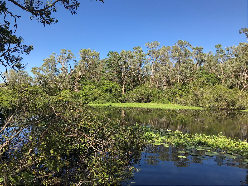
Figure 1. Ten Mile Swamp on the Mitchell River floodplains. Photo by Bianca Molinari.
The Mitchell River, located in tropical northern Australia, has a predictable wet-dry climate with the majority of rainfall (>80%) falling across the catchment between December and March each year, which creates vast inundated floodplains. The Mitchell River catchment has very little agricultural and urban development and no major dams.
Its rich biodiversity, Indigenous land and water use, coastal fisheries and coastal shorebirds relies on its free-flowing waters. Agricultural expansion and associated development of water resources is planned for the region, and this has created a need for tools that can identify regions with high ecological value that may be endangered. Identifying ecological hotspots, areas with high ecological value (eg, productive habitats), is one of the first steps to ensure these floodplain ecosystems are not impacted by development.

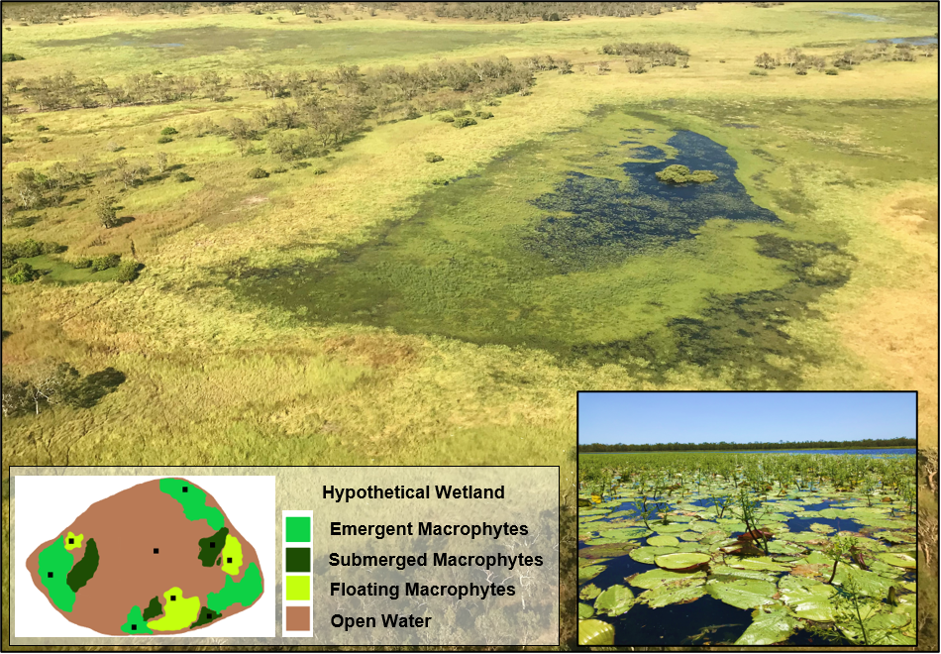
Figure 2: A) Aerial view an unknown wetland on the Mitchell River floodplain on 23/04/2018. B) A conceptual illustration of a hypothetical wetland. C) Racecourse Swamp from the ground. (Photos by Bianca Molinari)
In inland waters, algae are often seen as villains because people associate algae with waterbodies that contain too many nutrients (known as being ‘eutrophic’). In eutrophic waterbodies, the excess nutrients cause algae to grow abundantly. When the algae dies and sinks to the bottom they are consumed by bacteria and other organisms which can severely deplete oxygen levels. However, in healthy waterbodies, algae are the star of aquatic ecosystems, forming the basis of aquatic food-webs. Algae are consumed by small animals like macroinvertebrates which are in turn eaten by large animals such as fish. For example, in northern Australia, research has shown that much of the biomass of the iconic fish species Barramundi, can be traced back to the humble algae (Jardine et al, 2013).
Given the importance of algae, it is critical that river managers know where algae are growing and identify hotspots for habitat prioritisation to preserve ecosystem function in the face of potential water resource development and a changing climate. To identify those habitats across larger floodplains, we developed a method to predict rates of algal production on the Mitchell River floodplain.
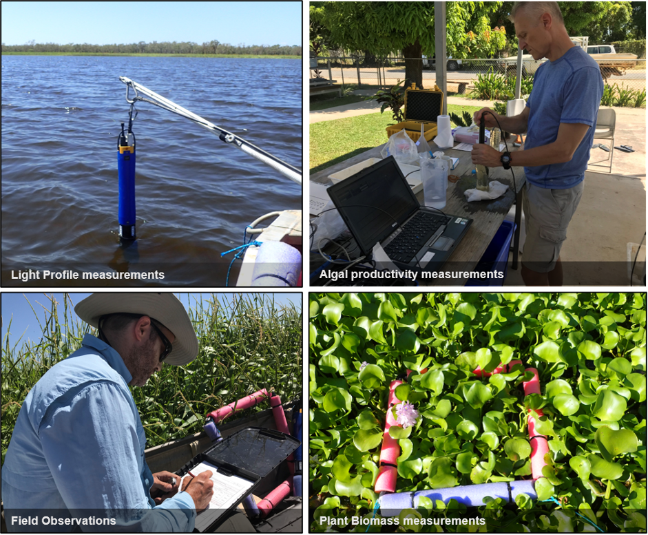
First, we conducted fieldwork on the floodplain at the end of the wet season in early 2018. We measured a range of environmental variables including turbidity, coloured dissolved organic carbon, nutrient concentrations and light. We then determined algal productivity and biomass.

Figure 3: Data collection on the Mitchell River floodplains. (Photos by Bianca Molinari and Ben Stewart-Koster).
Using this data from the field, we calculated the relationships between algae production and the environmental variables found on the Mitchell floodplain. Habitat type – as the type of aquatic plant (emergent, floating, or submerged plants) or its absence (open water) – and turbidity were identified as important predictors of algal growth (Molinari et al, 2021a). Using these relationships, we built a statistical model to predict rates of algal production. This model proved to be a valuable tool because it enables the prediction of algal production in places where fieldwork is not possible due to remote or dangerous conditions.
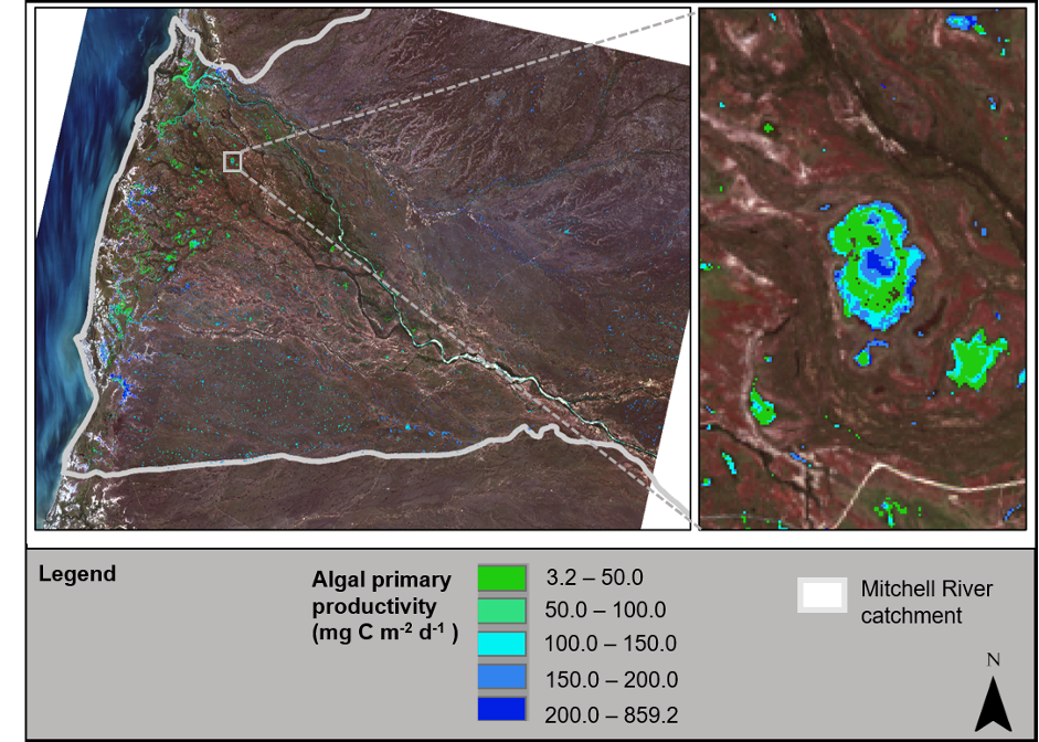
The second step was to combine the developed statistical model with remote sensing (Molinari et al, 2021b). Remote sensing is a valuable tool to retrieve data at large spatial scales and can be used to measure spatial variation in turbidity and habitat type, among other ecological and environmental data. We tested the combined use of the statistical model and remote sensing to predict hotspots of algal productivity and found good agreement between the fitted and observed values. From that, we used the remotely sensed image from the Landsat 8 satellite to predict algal production across the Mitchell River floodplains.

Figure 4. Algal primary productivity variation across the Mitchell River floodplain and Racecourse Swamp.
Our modelling suggests an algal production of 85 tonnes of carbon on the Mitchell River floodplain every day. When floodplain wetlands are connected to the main river tributaries, this production can be translated into fish growth across the whole catchment and coastal area.
Another key finding was that 94% of the floodplain algal production occurred in wetlands and secondary rivers across the floodplain rather than in the main rivers. These results indicate areas of high productivity and therefore highlight the importance of floodplain wetlands for ecosystem functioning.
The approach we developed in Molinari et al. (2021a) and (2021b) gives algae their rightful ecological value in natural systems. Incorporating approaches such as this into river management will inform water resources development to help preserve floodplain function. Importantly, while this method was developed for the Mitchell River floodplain, it has potential to be applied to floodplains elsewhere.
References
Molinari, B., Stewart-Koster, B., Adame, M.F., Campbell, M.D., McGregor, G.B., Schulz, C.P., Malthus, T.J., and Bunn, S.E. 2021a. Relationships between algal primary productivity and environmental variables in tropical floodplain wetlands, Inland Waters.
Molinari, B., Stewart-Koster, B., Malthus, T.J., and Bunn, S.E. 2021b. Assessing Spatial Variation in Algal Productivity in a Tropical River Floodplain Using Satellite Remote Sensing. Remote Sensing. 2021; 13(9):1710.
Jardine TD, Hunt R, Faggotter S, Valdez D, Burford M, Bunn S. 2013. Carbon from periphyton supports fish biomass in waterholes of a wet-dry tropical river. River Research and Applications.
Acknowledgments
We would like to thank the Kowanyama Aboriginal Land and Natural Resource Management Office for assistance with field collections. We acknowledge the Traditional Owners of the country from which the samples were collected in the Mitchell River catchment. This research was supported by funding from the Australian Government’s National Environmental Science Program through the Northern Australia Environmental Resources Hub. Thanks to Jane Thomas, Ben Stewart-Koster and David Salt for reviewing this article.
Want to know more about the Resilient Landscapes Hub's activities and our research into practical solutions to environmental problems? Stay informed about activities, research, publications, events and more through the Hub newsletter.
"*" indicates required fields