5 November 2025
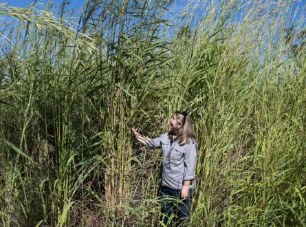
Invasive grasses have significant impacts on fire regimes and biodiversity across northern Australia. Some invasive grasses are now widespread, representing a significant risk and major management challenge.
The ‘Supporting the strategic management of invasive grasses’ project provides information to managers of protected areas and Indigenous ranger groups to support strategic management and reduce biodiversity impacts of invasive grasses. This includes the co-development of user-friendly mapping, monitoring and decision-support tools. The project, which focuses on gamba grass, para grass and olive hymenachne, runs from 2023 to 2027. It is a National Environmental Science Program (NESP) Resilient Landscapes Hub project and is co-led by Research Institute for the Environment and Livelihoods’ (RIEL) Dr Natalie Rossiter-Rachor and The University of Western Australia’s Professor Samantha Setterfield.
During 2024, the team worked with the Terrestrial Ecosystem Research Network (TERN) on a prototype mobile application that enables aerial mapping of gamba grass and other weeds at a landscape scale. The app can help weed managers to visualise gamba grass distribution, examine landscape-scale patterns of gamba spread, identify priority areas for control, and monitor and report progress. The researchers conducted on-ground and helicopter testing in Litchfield National Park, before presenting the app to weed managers from a range of NT and Queensland land management organisations. The app will be released as a national Ecological Monitoring System Australia (EMSA) protocol.
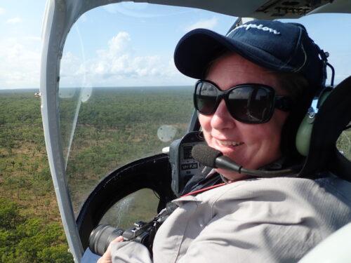
Dr Natalie Rossiter-Rachor conducts helicopter testing of a mobile application in Litchfield National Park. The app enables aerial mapping of gamba grass and other weeds at a landscape scale. Photo: NESP Resilient Landscapes Hub.
In 2024 Dr Rossiter-Rachor and Prof Setterfield also contributed to the National best practice management manual for gamba grass by authoring three sections of this important publication, which also discusses the aerial mapping app.
The development of the app has already made a significant impact. The team briefed the NT Parks and Wildlife Commission’s Executive Committee and park rangers on the survey results from Litchfield National Park, which led to the issue being raised at the NT Legislative Assembly and set the scene for funding commitments for gamba grass control.
These efforts are supporting Litchfield National Park to adapt its approach for managing gamba grass.
This project is supported by funding from the Australian Government under the National Environmental Science Program.
This story was originally published in the Research Institute for the Environment and Livelihoods (RIEL) Annual Report 2024.
Want to know more about the Resilient Landscapes Hub's activities and our research into practical solutions to environmental problems? Stay informed about activities, research, publications, events and more through the Hub newsletter.
"*" indicates required fields