Ro Hill
CSIRO
A huge 3D map of the Kimberley’s Fitzroy River catchment has facilitated knowledge sharing to inform decision-making around caring for Country and development planning.
The work has had impacts at levels ranging from the Ministerial via the North Australian Indigenous Reference Group, to the personal:
[The project] brought me back to life, it brought me back to understanding what is important.
– Ngarinyin Traditional Owner
Do you love maps? Maps are a great way to show and share knowledge and, in a location where significance of place and connection to Country is really strong, there’s one map that’s really turning heads. And it’s not just the map itself – it’s how it came to be, how it’s being used and what it’s being used for that’s making a difference.
Traditional Owners from eight different language groups have come together to build a huge 3D model of the catchment and to discuss the future of the river.
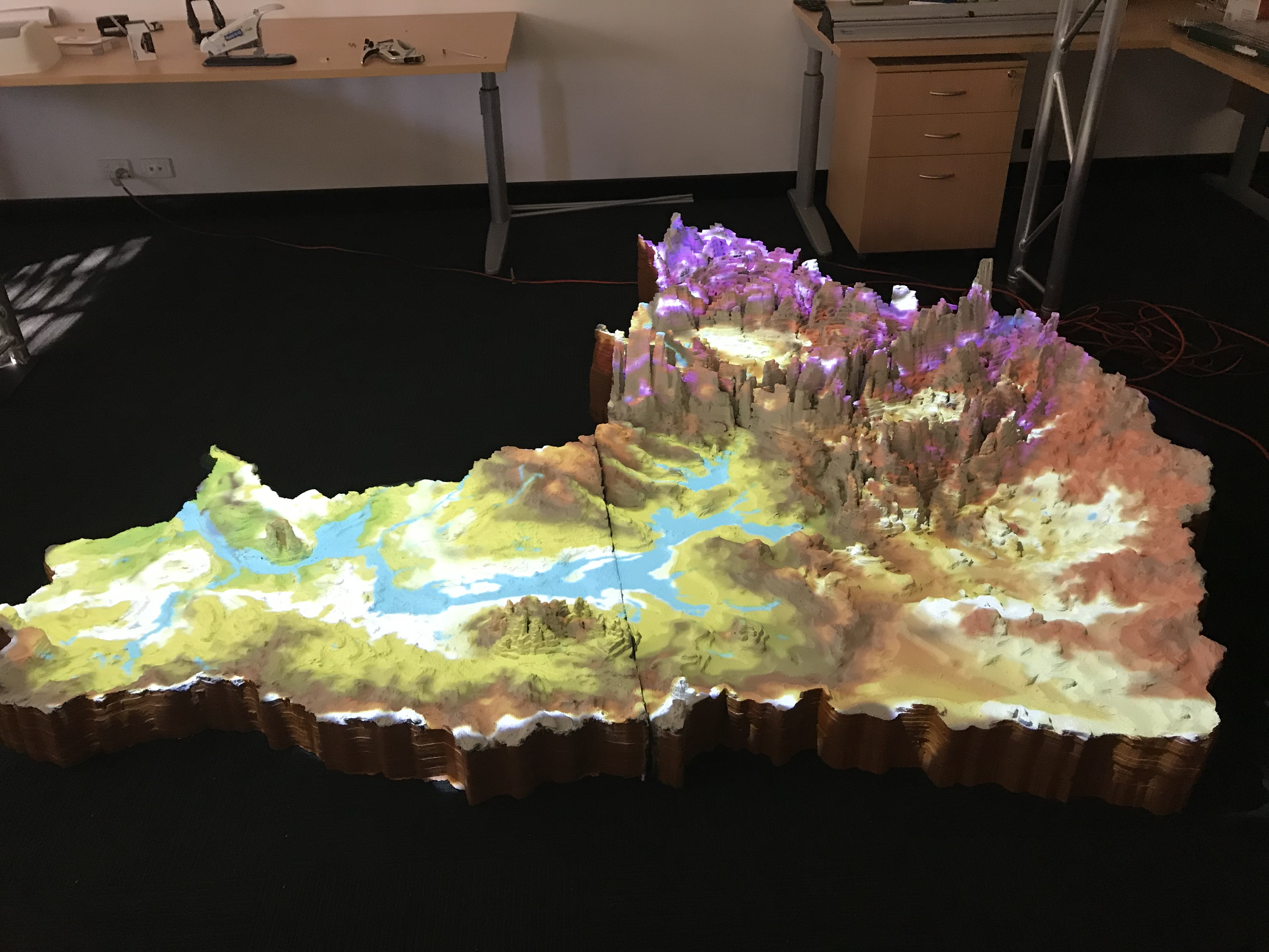
3D map with projected data. Photo by Ro Hill.
In the Kimberley’s Fitzroy River catchment, NESP research is supporting Indigenous land managers to effectively use both scientific and Indigenous knowledge to influence decisions to meet their aspirations for Country. And it’s happening through co-research, where land managers themselves co-design, use and test a culturally tailored method for showing and sharing knowledge around a topic of their choice.
Here, Traditional Owners from eight different language groups have come together to build a huge 3D model of the catchment and to discuss the future of the river. They’ve used the 3D map as a tool to show and discuss where important places are, and what’s happening where. They’ve explored concepts around water flow, water rights, the importance of flood and fire, and the various types of development that exist along the river.
They’ve also undertaken influence mapping to prioritise and understand decision contexts. Different information layers have been projected onto the map, adding detail to discussions, and pins, beads and stickers have been used to mark locations and explain stories (importantly these can be removed to protect knowledge). Kids have been part of the process giving it extra currency and helping with sharing knowledge between generations.
The map and subsequent discussions around the Fitzroy River have reached nearly a hundred local adults and over a hundred children in the Kimberley.
The impact of the work is clear in feedback from Traditional Owners:
[The project] brought me back to life, it brought me back to understanding what is important – it brought me back to understanding why people like us put ourselves in the front line and in jobs like this. Because when you put yourself in a job like this, it’s not just a job – it’s larger than that, it’s a lot more important.
– Presenter, February 2019
[The research is] …very valuable. Since starting with the project, made me aware of a lot of things. Learning about the river from scientists, I’m learning from elders, learning from other groups, they’ve given me a lot of insight about my Country.
– Workshop participant, 2018
Getting together from different language groups [was valuable]. Resources were very good, seeing new things like the [interactive] projector and 3D model.
– Workshop participant, 2018
More of these meetings are needed so it really sinks in. We need more of these meetings.
– Workshop participant, 2018
I ended up staying because I found it interesting and wanted to be involved … this NESP project has come on board with us to help us in different ways – both way learning …. I hope it keeps going.
– Presenter, 2019
The 3D model was easy to understand and see. Most of our learning is from seeing and hearing.
– Workshop participant, 2018
Workshop for the 3D map in the Fitzroy River catchment. Photo by Rachel Buissereth.
All this work is contributing to achieving a sustainable future for the national Heritage-listed catchment, and more specifically to planning for the proposed national park, for water allocation decisions and for better managing Country.
The research is also making waves beyond the Fitzroy catchment. The project team was invited to present to the Indigenous Reference Group of the Northern Australia Ministerial Forum, with a First Assistant Secretary saying that the research “was extremely helpful in shaping the IRG thinking”. It’s also been embraced by senior policy and program managers in the Indigenous Affairs Group at the Department of the Prime Minister and Cabinet – after seeing a video of one of the project workshops, a senior staff member commented,
It’s such an engaging way to show Country, to show the complexity, to show systems, to show so much. It’s so powerful.
– Program manager in the Indigenous Affairs Groups, Department of Prime Minister & Cabinet
The team is already making plans to extend the map to show underlying groundwater systems and to improve its transportability. They also hope to assist other Traditional Owner groups through similar knowledge sharing tools (requests are coming in!).
To help spread the message, the process of creating, building, and sharing the map, and other tools, are going to be explained in the Our Knowledge, Our Way Guidelines currently being developed in collaboration with the International Union for Conservation of Nature.
Research outputs
Factsheets
Videos & presentations
Project webpage
Attributions
![]()
![]()
CSIRO
NAILSMA
CSIRO
CSIRO
The University of Western Australia